All in a day #3 Hobart, Tasmania

Part 3 of “All in a day” takes me and two good friends to see the highs and more highs of Hobart town!

Hobart – the highs and the higher

January 2023

Travel companions: three enthusiastic Australians from the west

Our first morning in Hobart, Tasmania started like most days during our Tassie travels. Coffee and breakfast were on the agenda. We arrived in Hobart the previous day – all of us had met at MoMA (Museum of Modern Art) and ended our day with drinks at the Shamrock before sending Elaine on her way to help prepare for a wedding.

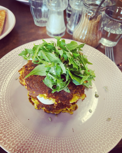
The previous morning, Leanne had enjoyed a delicious breakfast at the café down the road from our digs, Straight up. A vegetarian café with a delightful selection of vegetarian and vegan options and great coffee.

We were heading up the mountain that looms over Hobart town, kunanyi (Mt Wellington), that morning, so we headed to Straight Up for breakfast which was incredible. Some takeaway donuts were purchased for snacks should we get hungry during our mountain adventure!

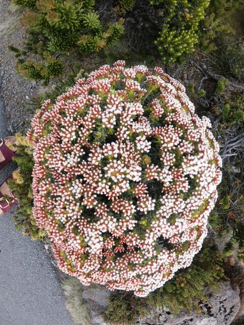
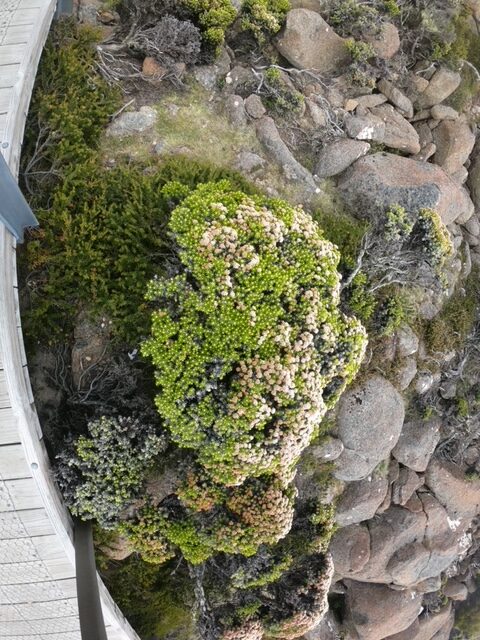
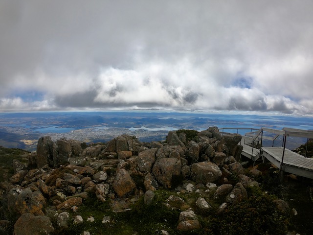
 Kunanyi and its foothills are the traditional lands of the Muwinina people. It is situated on an 18,011-ha reserve on the doorstep of nipaluna, lutruwita. The mountain is 1270m high and features some fantastic dolerite rock formations and a range of alpine vegetation. Kunanyi has a range of walks and hikes suited to climbers of all experience levels. The truly fit (or truly crazy) cycle to the top and enjoy a downhill run.

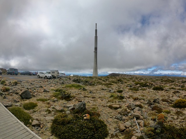
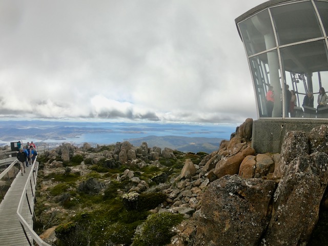
We drove our car up. The mountain is very close to Hobart city centre, and it took us about 45 minutes to reach the top. We were treated with a clear view and completely still conditions. The last time I had summited Wellington, I was making snow angels, and it was the middle of winter. The locals say it is a mountain of many moods.

We took advantage of the ideal conditions, explored the boardwalks, and ventured part-way down the zig-zag trail to get some photos. Tourists in their droves took selfies and group photos from every vantage point. The quiet side of the mountain where the Zig Zag trail starts was the most peaceful part.

Photos snapped and views admired; we decided that a swim was in order (as you do when in Tassie and the temperature is over 23 degrees). We chose the shores of Sandy Bay under the shadow of Wrest Point Casino, Australia’s first casino.   Sandy Bay is a well-to-do suburb in Hobart, not far from the city centre, with beautiful beaches on the banks of the Derwent River.

The surf lifesavers were set up on the beach, and the sun was shining, so we changed and plunged into the cool waters of the bay. Nice once you were in! The water was clear, and the bottom sandy like its namesake.

We devoured the delicious donuts from Straight Up. They were amazing, filled with chocolate, jam, and custard, and coated in sugar. Then, sand and sugar-coated, we showered in the freshwater showers, got dressed, and went to find a supermarket for our supplies back at the hostel were running low.

It’s a good time to talk about our digs. We decided to stay at the Pickled Frog, a backpackers in Liverpool Street. Leanne had booked the deluxe apartment, “Frog Apartment,” with her own kitchen, bathroom, and a chandelier! Wendy and I went for the shared room with the general hoi polloi. I am no stranger to backpacker accommodation, so I expected lots of young people and possible loud noise, which is pretty much what it was. However, it was okay for a few days and had us situated in the middle of Hobart, close to the restaurants and a walk from Salamanca Place.

Sleep was broken with comings and goings all hours of the night and day and alarms going off super early for those who lived and worked in Hobart. However, it was reasonably priced, and the people running the hostel were super friendly and helpful. I will also say, I am no stranger to broken sleep and noisy nights being a frequenter of music festivals – but maybe my youth hostel days are over?

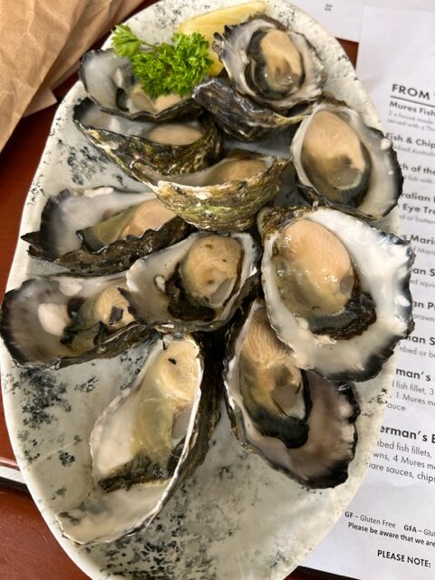
We returned to the hostel for a rest before the evening plans for eating oysters and taking in the docks commenced. The previous night had been spent at a delicious Greek Restaurant, Mezethes Greek Taverna, in Salamanca Place. The staff really went out of their way to make us comfortable and welcome. The food was deluxe, and we started with a small portion of oysters.

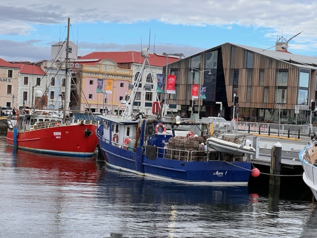
So we decided that more oysters were in order – Mures on the docks was my choice for a seafood feast. The multi-award-winning Mures is a Tasmanian institution. The Mures have served quality fish for over 45 years from various locations around Hobart.  

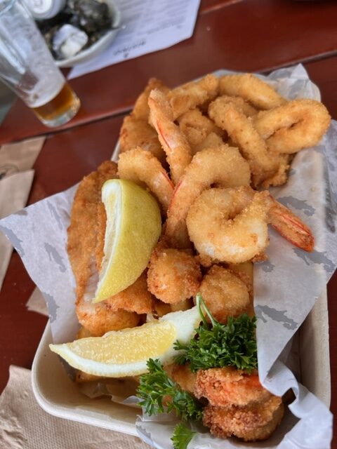
The seafood did not disappoint. We washed down fresh oysters with Tasmanian beer and feasted on a shared seafood basket. The downstairs part of Mures, where we dined, is very casual, and the food is more suited to families and big gatherings. Whereas upstairs, the posh part of Mures serves seafood but in a more refined manner.    We finished our massive meal with huge scoops of ice cream from the ice creamery inside the restaurant.

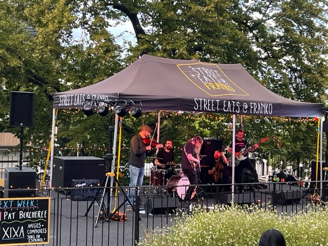
With hunger sated (or over-sated), we started our stroll back to the hostel, only to discover a shindig in progress in the local park. An Irish-style folk band had the crowd dancing and clapping – Craicpot was their name, and Irish jigs were their game. After eating and drinking so much, a wee dance was just what we needed, so we stayed and jigged and clapped until the band finished their set.

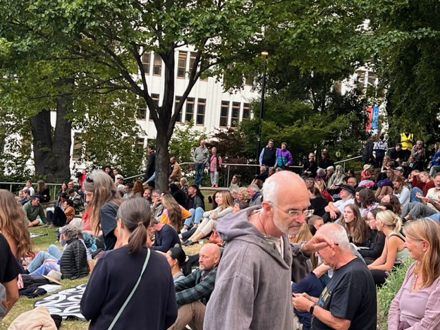
The park was crowded with locals and visitors eating food from food trucks and enjoying a family picnic on the lawn. It was the perfect ending to a day with us up mountains, swimming in the waters, and eating ourselves silly. Finally, we headed for bed (and hopefully sleep!) to ready ourselves for a visit to Salamanca Markets in the morning. Goodnight Hobart!

What’s the skinny?

  • Hobart is the capital city of Tasmania
  • Hobart is a port City with a rich maritime history.
  • Salamanca Market is held every Saturday morning on the docks – well worth a visit.
  • Mures Seafood are stalwarts of the Hobart restaurant scene – fish, chips and oysters washed down with a cold beer is a must! Or you can go fancy and dine in the upper deck section (same fish but fancier)
  • Mt Wellington/ kunanyi looms over Hobart (1270 m) and is worth a visit any time of the year. Snow in winter if the road is open, and amazing vistas in Summer.
  • The Tasman Bridge is a magnificent bridge – cross it at least once!
  • MoMA is a must – you can catch a ferry across from the docks or drive and Park. David Walsh’s collection is ever changing and will have you questioning everything.

Hiking and Biking Taroko Gorge – Taiwan

In November 2016, my partner and I traveled to Taiwan. One of the reasons we decided on Taiwan, apart from the fact that neither of us had been before, was because we had read an amazing account of a hiking and mountain bike adventure in Taroko Gorge.

Taroko Gorge is in the Taroko National Park on the east coast of Taiwan. The mountains are incredible, spoiled only by a massive concrete factory at the foot of the mountains. The limestone and marble is quarried for concrete and jade.

Before we traveled to Taiwan we had researched and planned to stay at Taroko Lodge, a home stay set at the foot of the Taroko mountain range.  This modest accommodation is run by Rihang and his family.  Rihang purchased National Park passes for us and assured us that he would be at the train station to pick us up when we arrived.

https://rihang.wordpress.com/

Taroko Lodge Homestay

True to his word, a white van was waiting at Xincheng station, and we were greeted warmly by Rihang.  Rihang spoke some English and his son, who we met later, also spoke quite good English. 

We stopped at the 7-Eleven for supplies and then settled ourselves into our accommodation. Taroko Lodge is the front part of the family home. The sleeping arrangements were very comfortable, with our own bathroom, and a shared living area. 

The only other guests at the time were a group of Americans who were leaving the same day as us. We had access to bikes the whole time so we could cycle into the town for snacks or meals.

The first morning, following a delicious home-cooked breakfast on the veranda, we were piled into Rihang’s  van with our bikes and transported to the top of the Taroko Gorge access road.  Rihang let us out with a few words of warning about the tunnels we had passed through on the way up.

We strapped on our helmets and waved goodbye to our host with some trepidation.  We had a brief discussion about the tunnels which were numerous and completely dark and the fact that we had no lights on our bikes!  Too late now, we were at the top and the only way was down.

Luckily there didn’t appear to be a lot of traffic on the roads, that was until we saw the stream of tourist buses making their way up the winding road.  Tourist buses that I wouldn’t like to meet in a pitch-black tunnel with no light!  We watched them approach and started our descent.  Once the last tourist bus had reached the top and the crowd of local and Chinese tourists had disembarked for their obligatory selfies and group shots, we decided it was time to go.

The initial part of the descent was fine.  We stopped along the way to take photos and to take in the incredible views. Our first tunnel was one of the shorter ones and there was light at the end so it was easy to navigate.  “We’ve got this!” we thought. 

The next tunnel was one of the super long ones, no light at the end of this one.  There came a point where we were literally plunged into pitch black. Fumbling for phone torches while avoiding potholes.  A huge sigh of relief when we reached the other end and had not been taken out by a tourist bus or fallen off.  We lost count of the tunnels and needless to say we got to the end without further incident.   Rihang’s white van was a welcome sight!

Gauging from the loose health and safety precautions of the previous day, we prepared for our upcoming hike on the Zhuilu Trail with some caution.  The region had experienced an earthquake in the months leading up to our visit and we were informed that parts of the trail were unstable.  The ranger let us onto the trail through a locked gate and checked our permits.  Apparently, they only allow a limited number of people on the trail per day.  The signs warn of not attempting the climb if you have a fear of heights or a heart condition.  Venomous snakes and falling rocks are also something to look out for.  None of this deterred us but we proceeded with caution, nonetheless.

A suspension bridge that spans the entire gorge is at the beginning of the trail.  We were two of maybe 5 other people hiking that day.  Breathtaking and exhilarating are the only words I can use to describe our adventure.  The trails were used by the indigenous inhabitants of this region for centuries before our arrival and later by Japanese forces in their bid to control the area. Towards the top of the climb the trail becomes  a  very narrow ledge of around 1m in width and there was nothing but a steel cable to hold onto and a 700m drop.  There was only one-way traffic on this stretch of the path.

We had a clear day, so the view was phenomenal.  Such experiences do not come along very often. If the thought of the Zhuilu Trail is enough to give you vertigo, there are plenty of places to hike or take in the view without balancing on a ledge.

The beginning of the “ledge”

That night we had a lovely meal at a local restaurant with our fellow travellers from America.  It was the eve of the US election results in 2016 and they were certain that Trump would not be elected.  They left early the following morning before we knew what the result was.  I often think about them and how disappointed they must have been.

The final morning was spent exploring the small village and venturing onto the deserted, rocky beach.  Rihang took us back to the train station and we said farewell to our lovely host before heading back to Taipei.

If you haven’t read the full account of our trip to Taiwan. https://www.xyzasia.com/home/first-time-taiwan-hiking-biking-train-trips

Bular Mial/Bluff Knoll, Stirling Range National Park, Western Australia

Fancy seeing the world from the top? A sunrise hike up one of Western Australia’s highest land forms will not disappoint.

We were up at 3:15 am on a Friday to climb WA’s highest mountain in the South West! Bular Mial/Bluff Knoll stands 1095m above sea level and it is classed as a grade 4 climb of 6.8 km. Bluff Knoll is part of the region in the Stirling Ranges originally inhabited by the Mineng and Goreng people. The mountain is a four hour drive south from Perth on the way to Albany. https://parks.dpaw.wa.gov.au/site/bluff-knoll-car-park-trail-head

The summit of Bluff Knoll at sunrise

The night sky was lit with bright stars and there was no cloud cover to be seen when we strapped ourselves in the car to drive 45 km to the base of Bluff Knoll. We were staying in accommodation at the Karribank Chalets in the Porongurups. A stunning part of the world and a first time visit for my partner and I.

Being around 6 degrees Celsius, we layered our clothing and made sure we had something warm to put on at the summit. Water, a small flask of coffee and some nut bars for sustenance, were jammed into our backpacks. I decided against taking the big camera and opted for my GoPro instead.

The car park was empty – we were the first to arrive! We paid our National Park Fee of $15/car at the Trail head using the automatic machine. This is a requirement of entering the park. Your docket must be displayed on the dash of your car. At 4:16 am we strapped on our head torches and found the beginning of the trail. Apart from the amazing skyscape all we could see was the imposing shape of Bluff Knoll looming above us in the dark.

The beginning of the trail lulls you into a false sense of security as it plunges down into a valley before rising. The paths is well maintained and made up mostly of steps fashioned into the granite rock and box wood construction. It wasn’t long before our glutes were singing and our heart rates pumping. After walking for around 30 minutes the path began it’s spiral around the Knoll. It was still dark so we were relatively unaware of the growing drop to our right.

It wasn’t long before we were warm enough to take off some layers and stop for a quick drink. We could hear another hiking group not far behind us and this spurred us on to keep going. Nothing like a bit of competition to inspire you!

Sunrise was supposed to be around 5:33 am and we started to see a change in the available light. The looming Knoll was very imposing. We also realised the sun was rising behind us so we quickened our steps to reach the summit in time. When the sun started to come up over the horizon we had reached a point on the climb where we could see the orange glow lighting up the peak. Perfect timing!

At 6:16 am we reached the actual summit, which is a bit further than you first think. Breathtaking! Our hiking competition arrived around 10 minutes behind us so we had the summit to our selves for the shortest time.

We were poised above the low cloud cover which made the view even more spectacular. There was not a breath of wind but it was certainly cold. Our layers were quickly relayered, coffee poured and we sat on top of the world looking down on some of the most beautiful country in the world.

Unable to bring myself to stand close to the edge like some of the young climbers who seemed hell bent on getting the most crazy Instagram photo they could, I lay down and peered over. Took my breath away. Sheer rock face all the way down. A sign warned us not to throw rocks off the edge as rock climbers could be below.

Once we had taken our photos and rested for a while we decided to head on down to see what scenery we had missed on our dark ascent. They say that “coming down is the hardest thing”, to borrow a song line from Tom Petty, and I must say my calves and knees are certainly paying the price 3 days later.

This climb is one I have always wanted to do and I was not disappointed. Come prepared, wear appropriate footwear and clothing in case of extreme weather on the summit. I used a stick that a previous hiker had kindly left by the beginning of the trail, and I would recommend walking poles especially on the way down.

If you love hiking and climbing the Porongurups are around 30 minutes away and boast amazing granite peaks with a number of climbs. We climbed up to Castle Rock and the Granite Skywalk which was well worth the walk. https://parks.dpaw.wa.gov.au/park/porongurup

The Sixty Foot Falls walk trail in the Perth hills

Sunday morning started out at around 22 degrees with a lovely fresh breeze and some sunshine with a promised high of 27 degrees on the horizon. Perfect morning for a hike!

Perth City is only around 45 minutes drive to Darling Scarp or as the locals call it, “the hills” area , and we picked out a trail we hadn’t walked before At Banyowla Regional Park in Gosnells.

Banyowla (pronounced ban-yow-la) recognises Banyowla a Nyoongar elder at the time of colonial settlement. The park has 550 species of flowering plants, 116 species of birds, 9 species of frogs and 8 species of native animals. The Ellis Brook flows seasonally from June to October, depending on rainfall.

There are 4 marked trails varying in difficulty and length beginning with the Easy Walk Trail, a 500m loop, the Eagle View Trail (moderate) a 430m return. The blue Wren Ramblue was listed as being easy and 2.8km return. The Sixty Foot Falls Trail (difficult) 2km loop with elevation.

The marker for the Sixty Foot Falls Walk

The walk we decided on, the Sixty Foot Falls Walk Trail took to us an elevation of around 150m and promised waterfalls and great views of the city. Waterfalls were definitely not expected as it is the middle of summer but views on a clear day are always a yes from me!

The place where the falls would be falling in the right season.

When we arrived at the gate we had to park on the road as the gate to the park was not open despite there being a sign stating that the gate was open between 6.00 am And 7.00 pm. No problem, it was only a short 1 – 2 km walk up the road to the beginning of our trek.

The walks were very clearly marked and maps were on display in various locations. We chose the “Sixty Foot Falls Walk Trail” which was around a 2km Loop that took in the water fall and the old quarry site.

After a quick look at the map we cleaned our shoes at the dieback station and started following the clearly marked arrows that took us up to the first lookout area.

The dieback shoe cleaning station

The path was pretty rocky in places and had steps cut out to enable easy climbing.

While climbing up we could see where the waterfall would usually be flowing and the view from the top was incredible. The city and surrounding suburbs clearly visible as it was a clear day.

Once we got over the top of the waterfall area we came across the old quarry with views from the top. This area is fenced so it is difficult to get too close, however, we could see that there was a road or track that allowed access to the quarry from the bottom.

The quarry was full of water which looked very inviting, however, there were signs warning that swimming might not be safe due to meningococcal risks. The surrounding cliffs are quite beautiful.

A video of just what is at the bottom of the Old Barrington Quarry

The quarry site, previously known as the “Old Barrington Quarry” is quite awe inspiring with huge cliffs that have been carved out by years of quarrying for stone.

The walks are suitable for both families and serious hikers. We saw some rock climbers in the quarry so it must also be popular with the climbing community

Climbers preparing for the rock face

I thoroughly enjoyed our hike to another of Western Australia’s hidden spots. We will definitely be back to see the water falling and the wildflowers blooming!

Road trip on the East Coast of Tasmania

This year’s Tassie trip took in the East Coast of Tasmania, Hobart and the Midlands. I am a native Taswegian and I try to get back there as much as possible. I might be biased, but Tasmania is an amazing holiday destination.

Ansons Bay

Ansons Bay which is a remote beachside paradise was where I started my journey. My partner and I own a property in this amazing part of the world. Ansons Bay is a place where people go to relax and mostly to fish. There are no shops or service stations in Ansons. The closest shop is 27km away in Gladstone or 40 km away in St Helens. Ansons Bay is only accessed by gravel roads and it has little to no mobile coverage apart from a phone tower that was placed a couple of kilometres short of the town.

The bay is idyllic and is set on an inlet. Access to the ocean and the Bay of Fires is via Policeman’s Point where there is a popular camping area. There are many walking tracks as well as coastal hikes in this area. A beautiful part of the world.

St Helens

St Helens is a fantastic little town that has just started to see the advantages of having a world class mountain bike track on it’s doorstep. With the opening of the latest Blue Tier to Binalong Bay track (a 40km ride) has come more bike shops and facilities for mountain bike riders. The town has bike washing stations and shower blocks. There is even a funky craft beer bar “The Social” and a new Wharf side restaurant that has just opened since my last visit.

While staying at Ansons Bay we popped into St Helens for Op shopping, coffee and groceries. We had lunch at the “Wharf Bar and Kitchen”. The food was so good, oysters and fish were fresh and local.

St Mary’s

After chilling out at Ansons Bay for two nights we set off and drove back through St Helens and made our way down the coast making a quick detour across the Elephant Pass to check out the quaint town of St Mary’s and the amazing views of the ocean from the top of the pass.

A coffee stop in Scamander at a cool coffee shop in a sea container overlooking the beach and the aqua blue water. “Swims East Coast Coffee” gave us great coffee and a delicious toasted cheese and tomato on sourdough for breakfast.

Bicheno

From Scamander we meandered down the coast stopping at Bicheno, a place I have faint childhood memories about as my family had a holiday house there when I was very small. Bicheno is a very pretty seaside town with an impressive coastline. Penguins are sighted here regularly at nightfall and the town is well-known to tourists for this fact. We shopped in the local craft market, “Makers Creators” and checked out a local artist in residence Anita Bacic’s Camera Obscura she had set up in a caravan by the sea.

Freycinet Peninsula

Next stop was Freycinet Peninsula and a 2.5 hour hike into Wine Glass Bay, just recently voted one of the worlds top ten beaches. This region never fails to impress. The hike up to the look out is manageable for most people and the view from the top is incredible. We continued down to the beach so we could put our toes in the blue ocean and experience the white sands. Just stunning! There were people swimming and a wallaby or two on the sand, yachts floating in the bay made for beautiful photos and viewing opportunities. The walk down onto the beach was fairly easy but of course once you go down you must then head back up at some point! Great cardio work out on the way back. I counted 840 steps!

When we had recovered and rehydrated from our amazing hike we set off on the final part of our journey for that day to Triabunna where we were staying the night before heading to Maria Island in the morning. Triabunna is a crayfishing town and it is also the place where the Maria Island ferry departs from. We stayed in a Deluxe cabin at the Triabunna Caravan Park. Very comfortable after roughing it at Ansons for a couple of nights. We had fish and chips from the “Fish Van” on the jetty. A bustling and busy business with delicious food!

Maria Island

The following morning We had the 9.00 am ferry to Maria Island on the Encounter Maria Ferry. A very comfortable boat with all the mod cons. The night before we had shopped for lunch items and snacks as there is nothing available on the island aside from some fresh water. The boat sold coffee and tea and snacks.

Maria Island is very well known for a couple of reasons:

  • It was a penal colony and has still got some significant structures on it for viewing purposes.
  • It is a wildlife sanctuary known for being a place where animals can live disease free. For example the healthy Tasmanian Devils have been raised here for a few years now following the terrible outbreak of facial tumours, and the wombats on the island are also free of the terrible mange that afflicts many of the Tasmanian wombats.

The following pictures are from Maria Island and the incredible wildlife we saw and had very close interactions with. We hired bikes and rode around the island. Most of the island is fairly flat with the exception of Mount Maria which would be more of a day hike. The roads are gravel and many of the tracks take you close to the coast line. Absolutely stunning beaches and landforms and views of the mainland Tasmania.

Before you leave for the island you are asked to take “the Maria Island pledge” and pledge not to touch or unnecessarily disturb the wildlife, in particular, the wombats. The wombats really did not give a hoot about us, they grazed very close to where we watched them and trusted us to be near their babies. We saw mothers with babies in their pouches, babies laying beside their mothers, lone wombats, wallabies, Cape Barren Geese, Tasmanian Native Hens, roos and echidnas. I feel very privileged to have experienced this and I hope it remains a sanctuary for ever.

You can camp on the island and also stay in dormitory style accomodation, however, there is no power on the island and you must bring everything with you. Showers, toilets and fresh water is available for campers.

The ferry does numerous trips to the island and back and costs around $45 for an adult return. The bike hire is extra and was about $50 for the day. We had originally booked to come back on the 5.00 pm (last) ferry but changed our mind and came back on the 3.30 boat. This was easy to change with a phone call to the ferry company.

Hobart

We reached Hobart in time for an evening drink and dinner in Salamanca. We stayed in Macquarie House in the centre of the city, an Airbnb with shared bathroom and comfortable amenities. Hobart would have to be one of my favourite cities in this world. It’s small but has that big city vibe. It’s arty and grown up and comfortable in its own skin. The following morning which was a Sunday we made our way to the Bathurst Street Farm Gate Market. A lovely bustling inner city market with fabulous food trucks, fresh produce, live music and great coffee. While being a fan of the huge Salamanca Market which is run on Saturday mornings on the docks I must say it was lovely to experience another type of market in this vibrant city! A lovely start to our morning before we got on the road again.

On our drive back up to Launceston we stopped in Richmond to look at the oldest bridge in Australia. Next stop was Oatlands for coffee and cakes at a tea house. We came across some lovely people spinning wool in the streets.

Richmond

We then took the Nile turnoff and went cross country to the beautiful historic town of Evandale. Unfortunately we missed the Sunday Markets at Evandale, they were just packing up so we went and had lunch at the Clarendon Arms Hotel in the beer garden. A very tasty lunch and a quick beer and then back on the road. Once again Tassie delivers in every way. See you next time!

Avon Valley Hikes: Paruna Wildlife Sanctuary and the Numbat Trail

So, quite some time back my 26 year old son said that he wanted to walk the Numbat Trail and I was keen as were a few others. So we finally settled on the 1st September at 11.00 am for our walk. I had emailed ahead to book and pay the $10 pp entry fee. Contact Paruna Wildlife Sanctuary

The beginning of the Trails; The Possum, The Quenda & The Numbat

The Paruna Sanctuary is situated in the Avon Valley around 1 hour east of Perth. It is a wildlife corridor that links the Walyunga and Avon Valley National Park’s, an area of around 1 912 hectares. The Australian Wildlife Conservancy operate the park where many species of wildlife live including the Western Quoll (Chuditch), the Black-Flanked Rock-Wallaby, Tamara Wallaby, Woolies, Quenda and Brushtail Possum.

The date approached and leading up to the Sunday we were due to walk the weather became increasingly nasty. On the Sunday morning the Bureau of Meteorology clearly stated that storms were expected and that the wettest time of the day would be the middle part. Both my son and I checked the radar and cheerfully said to one another that it didn’t look too bad up in the Avon Valley. We drove up to Paruna in torrential rain still chatting and hoping against hope that the rain would “rain itself out”.

Well lo and behold it stopped raining when we arrived and there was “enough blue sky to make a pair of sailor’s trousers” (a saying my grandmother was oft to use) and we enthusiastically exited our cars and put on our wet weather gear. We had already decided before we arrived that we would do the 12 km Numbat Trail. There being 3 options of varying lengths and difficulty. The Numbat being the most challenging.

The first part of our walk was punctuated by showers but nothing too wild. I was quite disappointed that the skies remained grey because being the photographer that I am it’s all about the light! The trail was well marked and maintained. We stopped periodically to look out from the various look-outs and to have a quick drink or snack.

The wildflowers didn’t disappoint and there was a healthy flow of water in the waterfalls and streams that we passed. We reached the point where the Numbat Trail takes a turn and leaves the main trail to begin the loop. One of our party decided that she would turn back and meet us at the beginning of the main trail and the rest of us soldiered on.

The loop was probably the most challenging part of the walk as it wound it’s way up to the highest point of our journey. The surrounding landscape was quite clear with many grazing areas. As we ascended the steep incline we saw mobs of grey kangaroos who stopped their grazing to gaze at us with curiosity and we also noticed that there was mobs of grey clouds approaching accompanied by howling wind. When we reached the very top we were hit by gale force winds and horizontal rain. There was nowhere to shelter so we crouched behind some shrubs.

Absolutely drenched, we decided that it was best to keep moving. I abandoned all hopes of taking amazing panoramic photos of the view and the surrounding bushland and jammed my camera into a plastic bag for the downhill descent.

The water was, by this time, flowing under our feet and some of us were beginning to feel that first squelch that meant that our shoes had finally given into saturation. None of this, however, took from the beauty of the surrounding bush and landscape. I only wish that there had been a break in the rain so we could stop and take in the beauty of the elevation.

When we got back to our fellow-walker , she too had tales of trying to huddle under the bushes and even attempting to get under the picnic table! The rest of the walk back was really wet but I did manage to pull my camera out for one attempt at photographing some drenched Yellow-Tailed Black Cockatoos.

The entire walk took us 4.5 hours and we were suitably exhausted and very very wet when we got back to our cars, by now the only cars in the carpark! The hot shower and glass of red wine was very welcome when I got home. I am definitely returning in the finer weather to do this walk again. Unfortunately the park closes at the end of September so I might not get there this year. Oh well, there is always next year.

If you would like to read about another hike close to Perth, click here https://www.lisabenjess.org/the-sixty-foot-falls-walk-trail-in-the-perth-hills/